

-
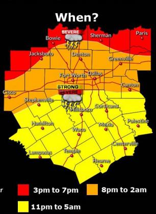 When?/Courtesy NWS
 -
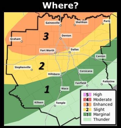 Where?/ Courtesy NWS
 -
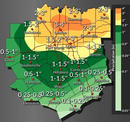 Rain/ Courtesy NWS
Hopkins County may stand in the way of severe weather this weekend, according to the National Weather Service.
A hazardous weather outlook has been activated for this afternoon in the areas between Red River County and Canton, according to the NWS. This could include thunderstorms with large hail, damaging winds, and isolated tornadoes all possible in these regions, the NWS said.
"These storms should form into a complex that moves south and southeast with a threat for damaging winds and hail," the NWS stated.
The remainder of Friday is mostly cloudy, with a chance of showers and thunderstorms this afternoon. Highs will be in the mid-80s, with the chance of precipitation at 30%.
Friday night is mostly cloudy, with showers and thunderstorms likely in the evening and then a decreased chance of showers and thunderstorms after midnight. Temperatures will be in the low 60s.
Saturday holds mostly cloudy with a slight chance of showers and thunderstorms in the morning. Skies then transition to partly sunny with a chance of showers and thunderstorms in the afternoon. Temperatures will be in the upper 80s, with south winds from 5 to 10 mph.
Saturday night holds partly cloudy skies with lows in the lower 70s and a 20% chance of rain.
Sunday is mostly cloudy with showers and thunderstorms likely, and highs in the mid 80s. Sunday night is cloudy with thunderstorms likely and lows in the upper 60s.
The NWS does not have any specific predictions for Hopkins County about flooding, although it states localized flooding may be possible with heavy rain. As much as 3 inches of rain could be possible in the northern part of Hopkins County, according to NWS data. Flooding is possible both in rural areas and in urban areas with poor drainage, the NWS states.