

-
 Drone footage of the flooded State Highway 71 bridge taken April 2019. Courtesy/Marna Martinez
 -
 Logs and other debris piled around SH 71/ Courtesy Marna Martinez
 -
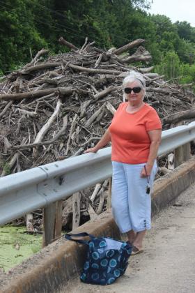 Texas State Highway 71 advocate Marna Martinez poses in front of the log jam at the bridge. Courtesy
SH 71 log jam has been building up for years — why it’s more critical than ever
During the wet spring of May 2018, Emblem resident Marna Martinez noticed a prodigious stench emerging from the forest near her house. In Martinez’s best approximation, it smelled “horrible … like sewage and dead stuff. Dead trees and rotting land.”
“It picked it up through the air conditioning of the car,” Martinez said.
She would later learn from the Texas Commission on Environmental Quality (TECQ) it was exactly that. Rotting vegetation in water emits both carbon dioxide and methane, according to a 2016 study by BioScience. These are the same gases given off by cattle feces, and Martinez wanted to know what was causing her to have to hold her nose near her own home.
She didn’t have to travel far to find the source, she says. A quick drive down the road to the South Sulphur River found debris — and lots of it — near the State Highway 71 bridge. Colloquially known as the log jam, the debris stretches from near Commerce in Hunt County almost to Cooper Lake in Delta County, affecting Hopkins County in between. Estimates done by Martinez via satellite imaging show the log jam could be 3-4 miles long or longer.
“It will probably never be resolved,” Martinez said.
But, Martinez says, for the first time in years, she has hope thanks to an initiative spearheaded by Rep. Dan Flynn (R-Canton) and the Hopkins County Commissioners Court.
HISTORY
The Sulphur River watershed in Northeast Texas is a major water supply for the growing region, according to a study by environmental group Freese and Nichols.
In 1906, Texas Senator Morris Sheppard of Texarkana wrote a letter to Washington describing the importance of the South Sulphur River and its importance to the region.
“We are very rapidly developing as a center for all classes of manufacturing,” Sheppard wrote 113 years ago. “Careful investigation should be done for opportunities of domestic trade.”
Since at least the 1960s, the Sulphur River has been the subject of small-scale irrigation projects in an effort to increase agricultural production, from which the Delta/ Hopkins/ Hunt County area derives the current South Sulphur River structure, according to Freese and Nichols.
In 1982, aerial photographs and survey done by the U.S. Army Corps of Engineers saw extensive flooding along the region, and farmers and local officials lobbied to get the Corps to undergo more extensive engineering projects such as levees to protect farm areas.
Channelization is the process of introducing straight cuts into a river which had previously been winding, which the South Sulphur River underwent from Fannin County to Hunt County on a large scale before 1987 by the Army Corps of Engineers.
In 1985, the Sulphur River Basin Authority was created to oversee the Sulphur River, its watershed and tributaries, and, according to its website, meets once a year in March and “from time to time” as needed.
The bridge, located in Hopkins County and created by the Army Corps of Engineers, spans 21 feet of the South Sulphur River and was originally built in 1963, according to the National Bridge Inventory Data (NBID). Constructed of concrete, this culvert-type bridge had a daily estimated traffic of 300 as of 2013, the NBID stated. Martinez thinks the bridge sees more traffic than that, though, as the day before the traffic was measured, the bridge was closed.
The bridge has received a 6 out of 10 condition score on its last inspection in 2011, according to NBID, and the condition of the culvert is in “deterioration or initial disintegration, [with] minor chlorine contamination, non-symmetrical shape, significant corrosion and moderate pitting.”
Martinez says there is no way to be sure of the bridge’s current condition, since you cannot reach it due to the log jam.
In 1991, the Army Corps of Engineers installed Cooper Dam and created what was then called Cooper Lake, now Jim Chapman Lake at Cooper Lake State Park. According to Martinez, this only worsened the log jam problem. According to a 2018 interview with the News-Telegram, Army Corps of Engineers public information officer Clay Church recalled “a rain event when the lake was under construction where FM 71, even before the lake was inundated, went under water.”
Martinez has tracked the conditions of the bridge almost every day since May 2018 and, in a color-coded graph, has found that the bridge has been closed almost as much as it has been open ongoing through 2019.
“I’ve lived in the area and traveled that road in the last 30 years almost every day, and I’ve seen it increasingly go down as far as appearances,” Martinez said. “As flooding became more and more, the slightest amount of rain would make the road flooded.”
According to Hopkins County resident Connie Milburn Westbrook, “It stays like this, and they won’t fix the problem. Everyone says it’s someone else’s responsibility.”
LETTER-WRITING CAMPAIGN
In early June 2018, Martinez submitted what is called a complaint investigation to the TECQ regarding the smell coming from the bridge and log jam area.
By late June 2018, the intergovernmental relations division of TECQ wrote, stating that while the investigation by TECQ was ongoing, “debris in the Sulphur River is not causing a hazard to the SH 71 bridge at this time.” An official letter sent to Martinez on July 20, 2018 noted that yes, there was a buildup of debris in the river and yes, water in the river was not flowing. However, TECQ stated it had spoken with the Texas Department of Transportation and TxDOT stated they had “previously removed debris from the river as it collected against the bridge” and repeated that “debris is not causing a hazard to the bridge.”
In a July 31, 2018 letter to TECQ, Martinez was willing to concede that the logs were not directly harming the bridge. “The debris may not be causing a hazard to the bridge at this time. In spite of this, the bridge isn’t the only issue with this area,” Martinez wrote [emphasis hers].
According to Martinez, the buildup of silt and logs makes the roadway a perfect avenue for the water that would normally take the course of the river to wash all over the roadway.
“Flood waters remain on flooded land without the ability to return to the river,” Martinez told TECQ. “This isn’t just one issue.”
Furthermore, she said, “TxDOT only attends to this area when flooding occurs. The bridge has withstood many floods over the past 55 years. Up-river flooding has continued to expand in those 55 years.
“How will the TECQ actually determine if an obstruction is determined hazardous?” Martinez asked.
Frustrated with the response she got from TECQ, Martinez reached out to U.S. Sen. John Cornyn, who forwarded her letter to TECQ. She contacted U.S. Sen. Ted Cruz, who told her the matter was outside his jurisdiction and directed her to speak to Rep. Flynn and Texas Sen. Bob Hall (R-Edgewood). She again contacted Cornyn, who directed her to speak to Hall.
A letter from a representative for U.S. Congressman John Ratcliffe similarly stated that debris was not causing a hazard to the TxDOT bridge.
At the same time during July 2018, Cruz co-introduced the North Texas Water Supply Security Act into the U.S. House of Representatives to “help address the looming water supply crisis facing North Texas,” according to Cruz’s press conference.
Although the nearby Lower Bois d’Arc Creek Reservoir, just 50 miles from the South Sulphur River was the target of this proposed legislation, Cruz’s office just one month earlier told Martinez that it was a “state matter which does not fall under the jurisdiction of the federal government.”
JURISDICTION AND LEGISLATION
Water rights issues in the U.S. are as complex and winding as the rivers themselves, Martinez found, as she began to investigate who might be responsible for clearing the jam.
The TECQ partners with the Sulphur River Basin to form a group called the Clean Rivers Program (CRP) which is responsible for water quality monitoring, assessment and stakeholder participation of surface water within each river basin in Texas.
But that’s only the water on the surface of the South Sulphur River. The State of Texas owns all water that flows through lakes and flowing streams and all fish that live there, according to Texas Parks and Wildlife (TPWD). A stream or river is flowing or navigable if it retains an average width of 30 feet, even if it is dry part of the year, TPWD says.
However, at the federal level, the Clean Water Act of 1972 supplements many state laws to “maintain the chemical, physical and biological integrity” and holds the scope of “navigable waters,” of which the South Sulphur River is one.
The Northeast Texas Municipal Water District depends on the water within the watershed for freshwater.
“They didn’t care,” said Martinez. “I said, what are you going to do when water stops flowing into Cooper Lake and you don’t have anything to pump out of there? They just didn’t feel it.”
Further complicating the issue is the land surrounding the bridge and log jam. Delta, Hopkins and Hunt counties each own their respective portions of land around the river. The river itself is owned by the State of Texas, but the bridge and channelization projects were created by the Army Corps of Engineers. The paving on top of the bridge is owned by TxDOT.
AGGRESSIVE ACTION
The first local government to respond to Martinez’s concerns was the Hopkins County Commissioner’s Court, who on July 9 urged TECQ to “take aggressive action” at removing debris from the South Sulphur River.
As of 1987, under section 11.097 of the Texas Water Code, TECQ is charged with removing obstructions from navigable waterways. In 11.097(a) states TECQ can do so either on its own motion or on written request from a commissioner’s court. 11.097(c) states it may request help from federal and state agencies including the Corps of Engineers, Texas National Guard, TPWD, and any districts and authorities created under Article III Section 52 and Article XVI Section 59 of the Texas Constitution.
“Our residents can’t get into work, so when the subject was raised, we immediately passed a resolution, and we hope it stirred up enough intention,” Hopkins County Judge Robert Newsom told the News-Telegram.
“It [the log jam] is not going to do anything but get bigger,” Newsom said. “Our commissioner’s court has been insistent. … It is good that citizens speak up about issues that matter, because it’s going to impact our environment and water supplies eventually. I think Hopkins County is willing to work, but we’re limited on resources, which the state has more resources.”
The City of Commerce, which lay on the other side of the highway, followed suit on Sept. 18, 2018 and similarly called on state and federal agencies to “take aggressive action.”
A year later, no such aggressive action had been taken. On Sept. 5, 2019 the Hopkins County Commissioners Court repeated its appeal to state and federal agencies for intervention, reading in a proclamation by Hall regarding the “severe and persistent” flooding problems surrounding the river and the bridge.
“Over recent decades, alternating periods of extreme drought and intense precipitation have caused trees along the river to die off, fall in and be swept by the current along with other debris to narrow, shallow, heavily silted areas by the bridge,” Hall’s statement read.
Hall was one more party to urge “aggressive action” regarding the deteriorating conditions surrounding the area.
It’s not just travelers who are affected by the fallen trees and accumulated silt, according to Newsom. Flooding “also impacts all the landowners as well as Cooper Lake. It appears that any solutions are going to have to be quite extensive and quite expensive,” Newsom told the News-Telegram in September.
In June 2018, TxDOT Paris area engineer Noel Paramanatham told the News-Telegram that TxDOT had no plans to close the bridge, but long term, the road needed to be raised. At an estimated cost of $200 per every foot of paving, according to the City of Sulphur Springs data, at a 15-degree angle, a total reconstruction of the SH 71 bridge would cost millions of dollars.
“It has to be substantially raised not to flood at all,” Paramanatham said. “The log jam is getting bigger and bigger, and every year more stuff is going underneath that bridge and it gets lodged in that log jam.”
TECQ responded to the News-Telegram’s inquires into the log jam by stating: “TCEQ has continued to work with TxDOT and other interested parties to monitor the debris in the South Sulphur River at the State Highway 71 bridge.”
MS. MARTINEZ GOES TO AUSTIN
If there’s one thing Marna Martinez, former mayor of Commerce, cannot do, it’s sit still. After being rebuked by Cornyn, Cruz and Ratcliffe, Martinez turned to her local representatives Hall and Flynn, as well as the Sulphur River Basin Authority (SRBA) and TxDOT.
After receiving emails from Martinez, Chris Spencer, chair of the SRBA stated the SRBA “wants to do what we can to address and hopefully correct the situation.”
Spencer and Martinez coordinated with Jeannie Ash of Flynn’s office. Once hearing of the situation, Flynn and his chief of staff, David Erinakes, went out and walked the land themselves and took pictures, Flynn told the News-Telegram.
“It’s a shame that it’s been a mess, but it’s one of those things that if you don’t know, you don’t know and you don’t recognize the seriousness of the problem,” Flynn said.
Flynn organized a meeting of all involved parties — TxDOT, county commissioners, Corps of Engineers, Farmers Cooperative Electric, TECQ, TPWD, Northeast Texas Municipal Water District and representatives from the offices of Hall and Cornyn.
“I think everybody was waiting for someone else to do something,” Flynn said.
The group finally gathered on July 17 in Greenville to discuss a solution to clearing the jam, the Commerce Journal reported.
“This is way outside my area of expertise,” Flynn told the group, as reported by the Journal. “We have to come up with some kind of solution before it becomes an even bigger issue.”
The group reportedly discussed two solutions to the problem: raising the road, as Paramanatham previously told the News-Telegram would be expensive, or dredging and widening the river, which the Journal reported would be possibly even more expensive.
Newsom told the News-Telegram he suggested burning the fallen logs, although he said he was told that the wet wood doesn’t burn well.
“I know he [Newsom] was speaking tongue-in-cheek when he said that,” Flynn said, “but that’s how those of us who were in the [Boy] Scouts approach a problem. It’s going to take a lot of heavy equipment to clear that out.”
At the resolution of the meeting, Flynn asked Paramanatham to discuss a proposal with the Corps of Engineers that Flynn could bring before lawmakers, the Journal reported.
Flynn also said he asked Hall and Cornyn’s representatives to “look for money that’s out there.”
“I am impressed with the fact that it’s only been 17 months,” Martinez said. “Everyone I spoke to in the beginning said, ‘They’re never going to do anything; nobody’s ever done anything.’ I said, ‘If you do not try, you’re definitely not going to get anything done.’”
In early October 2019, Martinez was able to post to her social media that Farmers Electric had spent time clearing away some logs from the side of the road near the bridge. While it was not all of the debris and none of the logs from the water, Martinez said she was encouraged.
“I stopped and told them thank you,” she posted. ”I know they were hired to do this job but it is getting done and in a big way.”
FUTURE
Improving the South Sulphur River, watershed and water flow will be crucial in the coming years, Martinez said.
“If you don’t maintain the situations you have, you’re going to run out of areas,” Martinez said. “My husband and I love to travel backroads, and you never see rivers or even creeks that look as bad as that one does.”
Martinez says those who travel on SH 71 to Cooper Lake along the log jam are getting a bad impression of the area, when in reality it’s a beautiful place she’s proud to call home.
The SRBA finds that conditions for us who live in the basin are much the same that Sheppard wrote about over 100 years ago: “quality of life and economic development within the Basin are needed to support environmental and social impacts.”
“We’re really pleased that folks stepped up, and we’re going to follow up with our office,” Flynn said. “It’s been there a long time, and we need to hold some feet to the fire because it needs to be done.”