

-
 Storm spotter activity/ Courtesy NWS
Hopkins County is in the path of a potentially severe storm with hail on Tuesday night, according to the National Weather Service.
Tuesday during the day has partly sunny skies with a 20 percent chance of showers and thunderstorms. Temperatures are highs in the mid 80s, with south winds ranging from 15 to 20 mph.
Tuesday night holds a 90 percent chance of precipitation with the chance of precipitation decreasing after midnight. Some thunderstorms may be severe. Isolated strong to severe thunderstorms are possible north of Interstate-20 and west of I-35 before daybreak, the NWS stated.
"The main threat will be damaging winds, but a few instances of large hail and an isolated tornado can't be ruled out," NWS hazardous weather outlook stated.
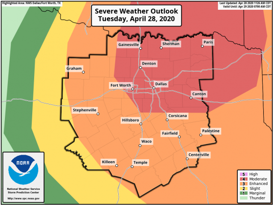
The NWS storm prediction center has updated its radar for storm severity to include the areas most likely to be affected to stretch from Dallas and Van Zandt counties in the south to Lamar and Fannin counties in the north and Bowie and Cass counties in the east, encompassing Hopkins county in the middle.
At this time, NWS does not have a prediction for how much rain is possible or if flooding is possible.